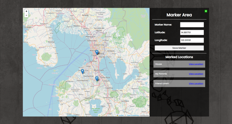
Interactive Map with Markers Using HTML, CSS and JavaScript with Source Code
Welcome to the Interactive Map with Markers project, a dynamic web application that transforms the exploration of geographic locations into an engaging and user-friendly experience. Leveraging HTML, CSS, and JavaScript, this project incorporates the Leaflet.js library to offer an interactive map interface. Users can seamlessly mark and save locations, providing a comprehensive solution for managing and visualizing specific points of interest. The dark-themed and visually appealing design, coupled with a responsive layout, ensures a seamless user experience across various devices.
This application introduces a novel way to interact with geographical data, allowing users to effortlessly click on the map to mark locations, input marker details, and save them for future reference. The integration of Leaflet.js not only empowers the map's interactivity but also enables users to view their marked locations with a single click. Join us on this exploration journey with the "Interactive Map with Markers" project, where simplicity meets functionality to redefine how we engage with geographic information online.
You may also check this simple HTML, CSS and JavaScript projects:
Features:
-
Interactive Map: Utilizes the Leaflet.js library to provide an interactive map where users can click to select and mark locations.
-
Marker Management: Users can input a marker name along with latitude and longitude coordinates. The application then saves these markers for future reference.
-
Marked Locations List: A dynamic list displays the marked locations, showing the marker names and providing a button to view each location on the map.
-
View Location: Clicking on the "View Location" button next to a marked location centers the map on that specific point.
-
Stylish User Interface: The project incorporates a visually appealing and user-friendly interface, with a dark theme and responsive design.
Technologies Used:
- HTML: The backbone of the project's structure and content.
- CSS: Stylesheets are applied to enhance the visual appeal and responsiveness of the web application.
- JavaScript: Enables dynamic and interactive features, such as handling user input, managing markers, and updating the interface in real-time.
- Leaflet.js: A JavaScript library for interactive maps, providing the map functionality and marker placement.
How to Use:
- Open the web page in a modern web browser.
- Click on the map to mark a location.
- Input a marker name along with latitude and longitude coordinates.
- Click the "Save Marker" button to save the marker.
- View the list of marked locations with the option to center the map on each location.
Sample Screenshots of the Project:
Landing Page

Full Map (closed marker)

How to Run?
- Download the provided source code zip file.
- Extract the downloaded zip file.
- Open the html file and you are now ready to go!
Conclusion:
In conclusion, the Interactive Map with Markers project showcases the power of combining HTML, CSS, and JavaScript to create a user-centric mapping experience. This application serves as a versatile tool for users seeking an intuitive and visually appealing solution to mark, manage, and explore geographic locations. With its dynamic interface and seamless integration of Leaflet.js, this project not only provides a practical way to mark and visualize locations but also sets the stage for further enhancements and features. Whether used for personal exploration, travel planning, or educational purposes, this interactive map demonstrates the potential of modern web technologies to redefine how we engage with spatial data. Explore the world at your fingertips, and witness the convergence of simplicity and innovation in the Interactive Map with Markers.
That's it! I hope this "Interactive Map with Markers Using HTML, CSS and JavaScript" will assist you on your programming journey, providing value to your current and upcoming projects.
For additional tutorials and free source codes, explore our website.
Enjoy Coding :>>
Note: Due to the size or complexity of this submission, the author has submitted it as a .zip file to shorten your download time. After downloading it, you will need a program like Winzip to decompress it.
Virus note: All files are scanned once-a-day by SourceCodester.com for viruses, but new viruses come out every day, so no prevention program can catch 100% of them.
FOR YOUR OWN SAFETY, PLEASE:
1. Re-scan downloaded files using your personal virus checker before using it.
2. NEVER, EVER run compiled files (.exe's, .ocx's, .dll's etc.)--only run source code.
Add new comment
- 1630 views

